Berkeley Township is located in central Ocean County along the Jersey Shore region and developed through a sequence of land-use shifts tied to coastal geography, resource extraction, and suburban expansion.
Its history reflects the interaction between inland pine forests, barrier island shoreline, and transportation access rather than early urbanization.
Originally sparsely settled, Berkeley evolved from Indigenous land use to colonial resource activity, later becoming a mix of resort-adjacent communities, planned residential developments, and conservation land.
Its modern form is the product of gradual adaptation rather than concentrated industrial or commercial growth.
Understanding Berkeley Township requires examining how land functioned before permanent settlement, how coastal access changed development pressure, and how postwar planning reshaped the township’s population and infrastructure.
Table of Contents
Indigenous Land Use and Coastal Geography
Before European settlement, the land that became Berkeley Township formed part of Lenape territory.
The region’s geography shaped Indigenous land use patterns. Pine forests, wetlands, bays, and rivers supported seasonal movement rather than permanent dense settlement.
The nearby Barnegat Bay played a critical role in fishing and transportation.
Lenape Presence
Lenape communities utilized the area for access to coastal and inland resources.
Land supported:
- Fishing and shellfish harvesting
- Hunting in pine forests and wetlands
- Seasonal movement between inland and coastal areas
European colonization displaced Indigenous populations through land acquisition, treaties, and force during the seventeenth and eighteenth centuries.
Colonial Settlement and Early Resource Use
European settlement expanded slowly into present-day Berkeley Township during the eighteenth century.
Unlike agricultural regions inland, Berkeley’s sandy soil limited traditional farming.
Early settlers relied more heavily on resource extraction and maritime activity than large-scale agriculture.
Early Economic Activity
Land use focused on:
- Timber harvesting
- Charcoal production
- Small-scale farming
- Bay-based fishing and trade
Settlement remained dispersed. Communities formed near waterways and resource sites rather than centralized villages.
Formation of Berkeley Township
Berkeley Township was established in 1875.
Its creation followed population growth and administrative reorganization within Ocean County.
The township was named after Berkeley, England, reflecting common nineteenth-century naming conventions rather than a local historical figure.
Early Governance
Municipal responsibilities were limited and practical.
Governance focused on:
- Road maintenance
- Property assessment
- Oversight of dispersed rural communities
Large areas remained undeveloped well into the late nineteenth century.
Transportation and Coastal Access
Transportation influenced Berkeley’s development unevenly.
Early road networks connected inland settlements but did not immediately produce large population centers.
Coastal access through Barnegat Bay supported fishing and small ports rather than industrial shipping.
Roads and Waterways
Key influences included:
- Bay and river transport
- Local road expansion
- Limited early rail access nearby but not central to township growth
The absence of major transportation hubs delayed dense development compared to other parts of New Jersey.
Nineteenth-Century Community Life
Community life in the nineteenth century remained localized and sparse.
Settlements developed around churches, schools, and maritime activity rather than commercial centers.
Population density stayed low, and land ownership remained fragmented.
Social Structure
Local institutions included:
- Churches serving small populations
- One-room schoolhouses
- Family-operated fishing and forestry operations
Berkeley remained rural well into the twentieth century.
Resort Influence and Shore Development
Proximity to the Jersey Shore introduced new development pressure.
As coastal tourism increased elsewhere along the shore, nearby inland areas such as Berkeley began supporting seasonal populations indirectly.
Barrier island development influenced land use without transforming the township into a resort itself.
Seasonal Activity
Development related to shore access included:
- Seasonal housing
- Supporting services for coastal communities
- Increased road traffic during summer months
Permanent population growth remained modest at this stage.
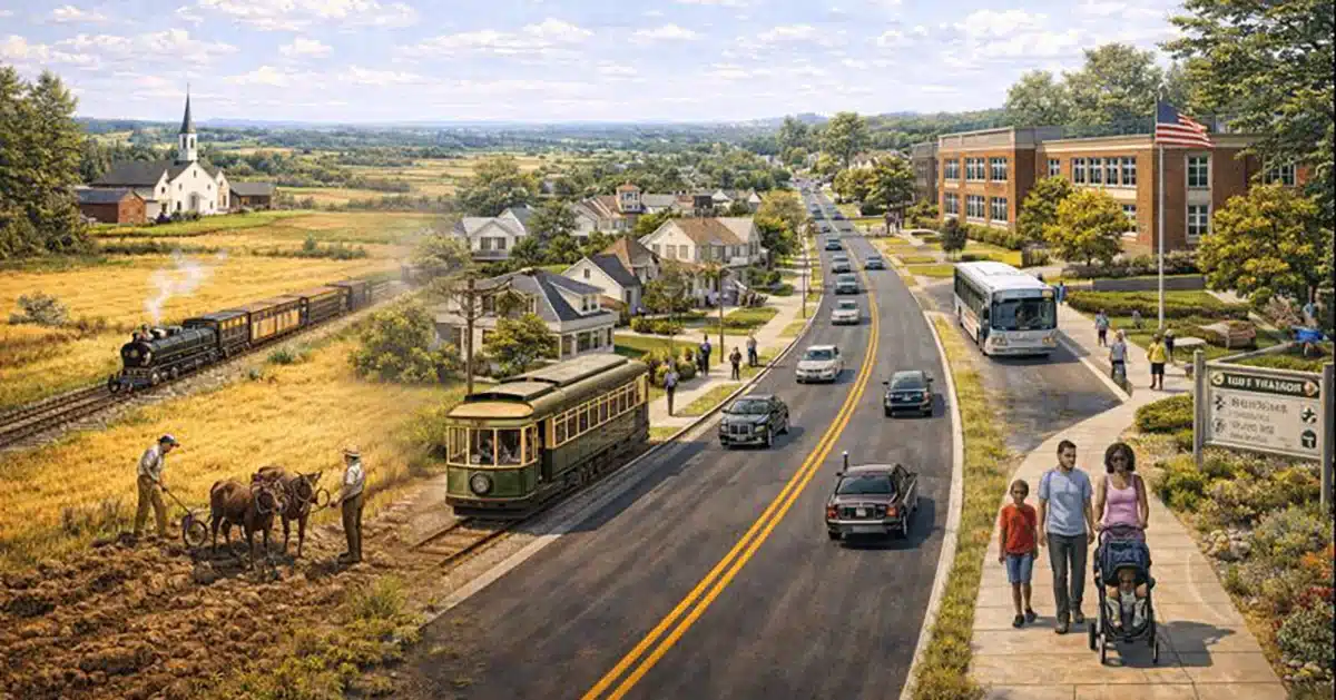
Twentieth-Century Transition
The twentieth century brought gradual but lasting change.
Mechanization reduced reliance on traditional resource-based labor.
Improved transportation increased mobility within Ocean County. Population growth accelerated slowly rather than abruptly.
Between the World Wars, Berkeley Township remained lightly developed with extensive undeveloped land.
Postwar Planned Development and Suburban Growth
After World War II, Berkeley experienced significant population growth.
Large-scale planned developments reshaped the township’s structure.
Residential communities replaced forested and undeveloped land, particularly inland from the bay.
Housing and Zoning
Development patterns emphasized:
- Master-planned residential neighborhoods
- Age-restricted communities
- Automobile-oriented road networks
Growth spread outward rather than consolidating into a town center.
Retirement Communities and Demographic Shift
Berkeley became known for age-restricted housing during the mid-to-late twentieth century.
Planned Communities
Notable development focused on:
- Retirement-oriented housing
- Community amenities
- Low-density residential design
This shifted demographic patterns and influenced municipal planning priorities, including healthcare access, recreation, and public services.
Environmental Preservation and Open Space
As development expanded, preservation efforts increased.
Large portions of Berkeley Township remained environmentally sensitive, including wetlands, forests, and bay-adjacent land. Conservation initiatives aimed to balance growth with protection.
Land Preservation
Preservation efforts focused on:
- Pine forest conservation
- Wetland protection
- Waterway and bay access management
These policies limited overdevelopment and maintained ecological continuity.
Berkeley Township Today
Modern Berkeley Township reflects layered land use shaped by geography and planning.
Residential communities, preserved open space, and limited commercial areas coexist within a large geographic footprint.
There is no traditional downtown core.
Key characteristics include:
- Planned residential developments
- Significant preserved land
- Proximity to Barnegat Bay
- Limited industrial and commercial concentration
The township functions as a residential municipality with strong ties to the surrounding shore region.
Why the History Still Matters
Berkeley Township’s development explains its dispersed layout, demographic composition, and land-use priorities.
Resource limitations, coastal geography, and late suburban planning defined growth.
Preservation efforts shaped the township’s final form as much as development did.
These forces continue to guide municipal planning decisions.
Berkeley Township Q&A
When was Berkeley Township established?
Berkeley Township was established in 1875.
Why did Berkeley remain sparsely settled for so long?
Soil conditions, geography, and limited transportation access delayed dense development.
What role did Barnegat Bay play?
The bay supported fishing, transport, and seasonal activity rather than large-scale commerce.
When did major population growth occur?
Significant growth followed World War II with planned residential development.
Why is Berkeley associated with retirement communities?
Large-scale age-restricted housing developments reshaped demographics in the twentieth century.
What defines Berkeley Township today?
It is a residential township shaped by planned development, environmental preservation, and coastal proximity.