
European borders often follow rivers, mountains, or historic treaties.
In the far north of Scandinavia, the frontiers of Norway, Sweden, and Finland meet at a single physical point marked by a concrete cairn in a remote Arctic landscape.
Known in Finnish as Kolmen valtakunnan rajapyykki, the structure represents the intersection of three sovereign states and the administrative lines that define them.
This site lies north of the Arctic Circle in the high plateau region often referred to as Lapland.
Its formation reflects centuries of shifting Nordic power balances, treaty negotiations, and cartographic precision.
Though geographically isolated, it holds clear legal and symbolic significance as a boundary marker grounded in international law.
Table of Contents
Geographic Setting of the Three-Country Cairn
The tripoint of Norway, Sweden, and Finland is located near the northernmost edges of all three countries on a plateau within the Scandinavian mountain range.
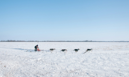
The cairn stands at approximately 69°03′N latitude, in a sparsely populated region characterized by tundra terrain, glacially shaped valleys, and subarctic climate conditions.
The nearest communities are small settlements tied to Sámi heritage and Arctic livelihoods such as reindeer herding, limited tourism, and cross-border trade.
Access differs by country.
From Finland, the most common route begins near Kilpisjärvi, with a marked trail and seasonal boat service across Lake Goldajávri.
From Norway, hikers approach through Signaldalen, while access from Sweden is more remote and less frequently used. Seasonal weather imposes strict limits on travel, with snow cover dominating much of the year.
The marker itself sits slightly offset from the exact mathematical intersection of borders due to historic topographic constraints when the original demarcation was performed.
Modern surveys confirm the legal boundary coordinates are fixed under international agreements.
Historical Development of the Border
The meeting point of these three states emerged from a sequence of Nordic treaties finalized in the eighteenth and nineteenth centuries.
For centuries, territorial control in this region was fluid.
The area was inhabited primarily by Sámi populations whose seasonal migrations predated modern national boundaries.
Scandinavian kingdoms and later the Russian Empire exerted overlapping claims over northern territories.
The legal framework of the present borders developed through key agreements:
- The 1751 Treaty of Strömstad between Denmark-Norway and Sweden establishing large portions of their frontier
- The Lapp Codicil attached to that treaty protecting Sámi cross-border herding rights
- The 1809 Treaty of Fredrikshamn, in which Sweden ceded Finland to the Russian Empire
- Subsequent nineteenth-century commissions that surveyed and demarcated the physical boundary lines
When Norway entered a union with Sweden in 1814, the frontier between them remained administrative rather than international.
After Norway gained full independence in 1905, the border became one between two sovereign states.
Finland’s independence from Russia in 1917 completed the framework for three distinct countries converging at a single point.
The original stone marker was replaced in 1897 by a more visible concrete structure to prevent erosion and clarify jurisdiction. It was later reconstructed in modern form to reflect precise geodetic standards.
Structure and Legal Meaning of the Cairn
Kolmen valtakunnan rajapyykki is an official international boundary marker jointly maintained by Norway, Sweden, and Finland.
The marker is circular and painted in colors reflecting national flags, with engraved indicators specifying the three countries. Unlike many inland borders that follow rivers or invisible survey lines, this site provides a tangible, accessible point of intersection.
Its legal function is defined by bilateral and trilateral boundary agreements.
Each country maintains its respective boundary segment up to the exact coordinate of the tripoint.
International law recognizes such tripoints as fixed reference markers anchoring broader boundary lines.
Key functional characteristics include:
- Surveyed and geodetically recorded boundary coordinates
- Recognition under Nordic border treaties
- Shared responsibility for maintenance
- Open civilian access within Schengen Area travel rules
- No permanent border controls at the physical site
The absence of fencing or guards reflects broader Nordic regional integration, yet the boundary retains full legal force. Jurisdiction changes precisely at the meeting line.
Regional and Cultural Context
The tripoint lies within traditional Sámi cultural territories and reflects layered sovereignty rather than purely modern state formation.
Northern Scandinavia has long been inhabited by Sámi communities whose livelihoods depended on seasonal movement across what are now national borders.
The 1751 Lapp Codicil specifically preserved certain migration rights, recognizing that rigid borders disrupted established patterns.
Modern border administration continues to account for these historic provisions, though regulatory frameworks have evolved under national law and European cooperation agreements.
The region participates in cross-border Nordic councils that coordinate infrastructure, environmental protection, and Arctic policy.
Tourism has grown steadily, with hikers and visitors drawn by the symbolic act of standing in three countries at once.
Yet the broader importance of the cairn lies not in novelty, but in its embodiment of diplomatic stability in a region once characterized by shifting imperial authority.
Strategic Significance in the Arctic Context
The tripoint occupies territory within the broader Arctic strategic zone governed by environmental agreements and NATO-aligned security structures.
Norway and Finland are members of NATO, and Sweden became a member in 2024.
Although the tripoint itself carries no military installations, the surrounding region falls within the northern European security framework.
Arctic infrastructure, sovereignty claims, and environmental governance have gained attention as climate change affects navigation routes and resource discussions.
Despite these shifts, the legal boundary at Kolmen valtakunnan rajapyykki remains unchanged. International recognition and treaty-based demarcation create continuity independent of political developments.
Comparative Perspective on European Tripoints
European tripoints function as fixed reference markers anchoring national sovereignty through treaty precision rather than physical barriers.
While Europe contains many border intersections, the Norway–Sweden–Finland tripoint stands out for its accessibility, clear marking, and historical continuity.
Its remote Arctic setting contrasts with heavily urbanized tripoints elsewhere on the continent.
Unlike contested borders in other regions of the world, Nordic frontiers have long been defined by negotiation, arbitration, and legal documentation.
The cairn represents the practical outcome of that tradition.
Three Country Cairn Q&A
Where exactly is Kolmen valtakunnan rajapyykki located?
Kolmen valtakunnan rajapyykki is located north of the Arctic Circle near Kilpisjärvi in Finland, at the point where the borders of Norway, Sweden, and Finland intersect.
When were the borders between Norway, Sweden, and Finland finalized?
Major boundary definitions occurred in 1751 between Denmark-Norway and Sweden, in 1809 when Sweden ceded Finland to Russia, and through subsequent nineteenth-century surveying commissions.
Can visitors freely stand in all three countries at once?
Yes. Under Schengen Area rules, visitors can move between Norway, Sweden, and Finland without passport controls at the tripoint.
Does the tripoint have political significance today?
The tripoint has primarily legal and symbolic significance as a clearly defined boundary intersection, supported by treaty and international recognition.
Why is the Sámi context historically important at this site?
The Sámi traditionally moved across the region before national borders existed, and the 1751 Lapp Codicil recognized cross-border rights for reindeer herding in acknowledgment of that history.