Linden is located in Union County in northeastern New Jersey and developed under conditions distinct from many neighboring municipalities.
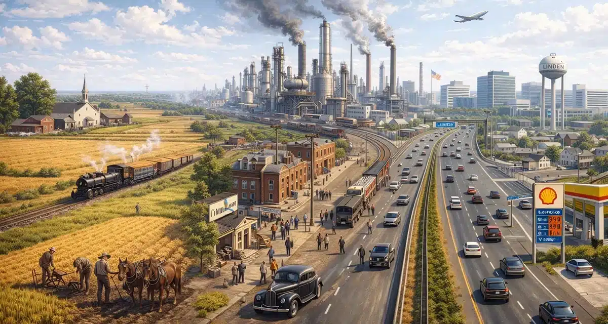
Its transformation from rural land to industrial center occurred earlier and more rapidly due to transportation access and regional economic demand.
While surrounding areas retained agricultural or suburban identities longer, Linden shifted decisively toward manufacturing and logistics. That shift shaped its zoning, housing patterns, population growth, and long-term redevelopment challenges.
The city’s history is best understood as a sequence of land use transitions driven by infrastructure rather than a single founding event or cultural movement.
Table of Contents
Indigenous Land Use and Early Geography
Before European settlement, the land that later became Linden formed part of a broader Lenape territorial landscape.
This region did not function as a population center but as a resource area integrated into seasonal movement patterns.
Natural features defined land use well before formal settlement. Wetlands, wooded areas, and nearby waterways supported hunting, fishing, and limited cultivation. Permanent structures were minimal, and land occupation remained flexible.
Lenape Presence
Lenape groups used the area as part of a regional network extending across northeastern New Jersey.
Land supported:
- Seasonal hunting and fishing
- Small-scale agriculture
- Material gathering from forests and wetlands
European colonization in the seventeenth century displaced Lenape communities through land purchases, treaties, and force, transferring land control to colonial authorities and private owners.
Colonial Settlement and Rural Land Use
European settlement expanded inland during the late seventeenth century.
The area remained part of Elizabeth Township and developed slowly compared to port-adjacent settlements.
Agriculture defined land use for more than a century. Farms were dispersed, and population density remained low. Roads existed primarily to move goods rather than support commerce.
Agricultural Patterns
Land was divided into large tracts worked by individual families.
Common activities included:
- Crop cultivation
- Livestock raising
- Supplying nearby towns and ports
There was no centralized village or commercial hub. Governance stayed minimal and dependent on Elizabeth Township.
Separation From Elizabeth Township
Linden became an independent township in 1861 during a period of widespread municipal reorganization across New Jersey.
This separation reflected administrative practicality rather than cultural distinction. As populations grew and infrastructure demands increased, smaller governance units became necessary.
Naming and Governance
The name “Linden” was chosen for its neutrality rather than a historical figure or geographic landmark.
At incorporation:
- Land remained largely agricultural
- Population density was low
- Industrial use was minimal
The township entered the industrial era largely undeveloped but geographically positioned for change.
Transportation Infrastructure and Regional Access
Infrastructure altered Linden’s trajectory more than population growth did.
Rail lines introduced in the nineteenth century connected the area to ports, labor markets, and manufacturing centers. Land near these corridors gained economic value rapidly.
Transportation access arrived before dense residential settlement, reversing the pattern seen in many surrounding towns.
Rail and Road Networks
Transportation advantages included:
- Rail access for freight and labor
- Proximity to coastal ports
- Later highway development
These factors positioned Linden for industrial use rather than small-scale commerce.
Industrial Expansion in the Late Nineteenth Century
Industrial development accelerated in the late nineteenth century as farmland gave way to factories and warehouses.
Manufacturing facilities clustered near transportation corridors. Zoning followed industrial demand rather than residential planning.
Early Industrial Growth
Industries included:
- Chemical production
- Oil processing
- Metal fabrication
Employment opportunities drew workers into the township. Housing developed alongside industrial zones rather than separately from them.
Linden’s physical layout began to take a distinctly industrial form.
Twentieth-Century Manufacturing Growth
The early twentieth century marked sustained industrial consolidation.
Major employers expanded operations, and Linden became a regional manufacturing center.
Population growth followed employment demand. Municipal services expanded reactively rather than through long-term planning.
Housing and Infrastructure
Development patterns included:
- Worker housing near factories
- Expansion of utilities and roads
- Increased municipal staffing
Industrial activity defined the city’s economic identity through much of the century.
Immigration and Population Change
Industrial growth reshaped Linden’s population profile.
Workers arrived from other U.S. regions and abroad. Immigration occurred in waves aligned with labor needs rather than cultural settlement patterns.
Community Formation
Population change led to:
- Neighborhood stratification by employment proximity
- Growth of religious institutions
- Expansion of local retail and services
Demographic composition shifted repeatedly as industries expanded and later declined.
World War II and Peak Industrial Activity
World War II intensified industrial production.
Manufacturing facilities supported wartime needs, particularly in energy, materials, and aviation-related sectors. Infrastructure investment increased, and employment reached peak levels.
Postwar demand sustained industrial activity for several decades.
Postwar Housing and Industrial Decline
After World War II, suburban housing expanded while manufacturing began to contract.
Automation, relocation, and regulatory changes reduced industrial employment. Some facilities closed or downsized, leaving underutilized land.
Economic Transition
Changes included:
- Decline of heavy manufacturing
- Expansion of residential neighborhoods
- Growth of automobile-based infrastructure
Linden entered a period of economic restructuring rather than abandonment.
Environmental Remediation and Redevelopment
Former industrial land required cleanup and repurposing.
Environmental remediation addressed contamination from decades of manufacturing. Redevelopment followed transportation priorities rather than residential densification.
Redevelopment Patterns
Land reuse focused on:
- Warehousing and logistics
- Distribution centers
- Commercial and service-oriented use
These uses aligned with Linden’s transportation advantages.
Linden Today
Modern Linden reflects layered land use rather than cohesive planning.
Residential neighborhoods, industrial zones, commercial corridors, and transportation infrastructure coexist within a compact footprint. Manufacturing plays a reduced role, replaced by logistics, retail, and services.
The city’s current form reflects adaptation rather than reinvention.
Why the History Still Matters
Linden’s development explains its zoning patterns, transportation emphasis, and economic structure.
Industrial land use shaped growth early. Redevelopment followed infrastructure rather than community redesign. The city evolved through functional necessity rather than planned continuity.
Linden, New Jersey Q&A
When was Linden incorporated?
Linden was incorporated as a township in 1861 and became a city in 1925.
Why did Linden industrialize earlier than nearby towns?
Transportation access and available land attracted manufacturing.
What industries dominated Linden historically?
Chemical processing, oil refining, metal fabrication, and aviation-related manufacturing.
Did Linden experience industrial decline?
Yes. Manufacturing declined in the late twentieth century, leading to redevelopment.
What defines Linden’s economy today?
Logistics, distribution, retail, and service industries.